(ORDO NEWS) — Magma beneath the long-dormant Mount Edgecumb volcano in southeast Alaska is moving up the Earth‘s crust, according to a study by the Alaska Volcanic Observatory using a new method.
The observatory’s new approach could lead to earlier detection of volcanic disturbances in Alaska.
At Mount Edgecumbe, computer modeling based on satellite imagery shows that magma rises to a height of about 6 miles from a depth of about 12 miles and causes earthquakes and significant surface deformation.
“This is the fastest rate of volcanic deformation we currently have in Alaska,” said lead author Ronnie Grapentine, an assistant professor of geodesy at the University of Alaska Fairbanks.
“Although volcanic deformation is not uncommon, activity at Edgecumb is unusual, as reactivation of dormant volcanic systems is rare,” he said.
An eruption is not imminent, Grapentin said.
The findings from the UAF Geophysical Institute and the US Geological Survey were published Oct. 10 in the journal Geophysical Research Letters.
The Alaska Volcano Observatory has partnered with the Alaska Satellite Center, another division of the Geophysical Institute, to process data in the cloud – a first for the volcanologist team.
Cloud computing uses remote servers to store data and provide computing services, so a researcher doesn’t have to download and sort data to process it, which can take weeks or months.
The research team began their work immediately after an earthquake swarm was spotted on Mount Edgecumbe on April 11, 2022. The researchers analyzed the previous 7.5 years of ground deformation recorded in satellite radar data.
Four days later, on April 15, the team received a preliminary result: the earthquakes were caused by the intrusion of new magma.
A small number of earthquakes started under Edgecumbe in 2020, but the cause was not clear until the deformation results were obtained.
Additional data processing confirmed the preliminary conclusion. The Alaska Volcano Observatory briefed the public on April 22, less than two weeks after the latest series of quakes near Edgecombe became known.
“We’ve done analyzes like this before, but new streamlined cloud workflows have reduced weeks and months of analysis to days,” said David Fee, coordinating scientist at the Alaska Volcanic Observatory at the Geophysical Institute.
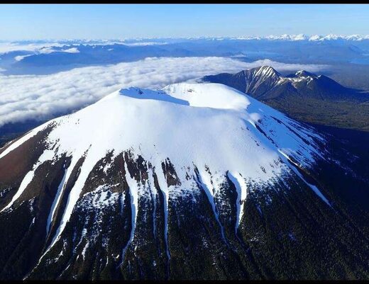
Mount Edgecumbe, 3,200 feet high, is located on Cruzoff Island on the west side of Sitka Sound. It is part of the Mount Edgecumbe Volcanic Field, which includes the domes and crater of the adjacent Crater Range.
Most of all, researchers were struck by a 10.5-mile diameter uplift area on the southern part of Kruzof Island, located 1.5 miles east of the volcano.
The upward warp began abruptly in August 2018 and continued at a rate of 3.4 inches per year for a total of 10.6 inches until early 2022.
Subsequent computer simulations have shown that the intrusion of new magma is the cause.
The new deformation-based analysis will enable earlier detection of volcanic disturbances, as ground deformation is one of the earliest indications. Deformation can occur without accompanying seismic activity, making uplift a key symptom to watch for.
The Volcano Observatory is taking a novel approach to other volcanoes in Alaska, including Mount Trident, located about 30 miles north of Katmai Bay. This volcano is showing signs of increased swell.
Mount Edgecombe shows no signs of an imminent eruption, Grapentine said.
“This magma intrusion has been going on for more than three years,” he said. “Before the eruption, we expect more signs of unrest: more seismicity, more deformation and, importantly, changes in the structure of seismicity and deformation.”
The researchers say the magma most likely reaches the upper chamber through a nearly vertical channel. But they also believe that the magma cannot move further up due to the thick layer of magma already in the upper chamber.
Instead, the new magma causes the entire surface to rise.
Mount Edgecumb is 15 miles west of Sitka, home to about 8,500 people.
The volcano last erupted 800-900 years ago, according to the oral history of the Tlingit, transmitted by Herman Kitka. According to this account, a group of Tlingit in four canoes camped on the coast about 15 or 20 miles south of the large smoke plumes.
A reconnaissance party in a canoe was sent to investigate the smoke and reported “a flashing mountain spewing fire and smoke”.
Franz Meyer, chief scientist at the Alaska Satellite Center, UAF graduate students Itian Cheng, Mario Angarita, and Darren Tan, and Aaron Wech of the US Geological Survey also contributed to the study.
The Alaska Volcano Observatory is a joint program of the Geophysical Institute, the US Geological Survey, and the Alaska Division of Geological and Geophysical Research.
—
Online:
Contact us: [email protected]
Our Standards, Terms of Use: Standard Terms And Conditions.


